


GREENDALE 5, Dearborn County, Indiana
About
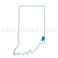
Outline

Summary
| Unique Area Identifier | 576773 |
| Name | GREENDALE 5 |
| County | Dearborn County |
| State | Indiana |
| Area (square miles) | 6.91 |
| Land Area (square miles) | 6.44 |
| Water Area (square miles) | 0.47 |
| % of Land Area | 93.14 |
| % of Water Area | 6.86 |
| Latitude of the Internal Point | 39.12618360 |
| Longtitude of the Internal Point | -84.84099450 |
Maps


Graphs
Select a template below for downloading or customizing gragh for GREENDALE 5, Dearborn County, Indiana


Neighbors
Neighoring Voting District (by Name) Neighboring Voting District on the Map
- GREENDALE 1, Dearborn County, IN
- GREENDALE 3, Dearborn County, IN
- GREENDALE 4, Dearborn County, IN
- LAWRENCEBURG 1, Dearborn County, IN
- LAWRENCEBURG 8, Dearborn County, IN
- LAWRENCEBURG 9, Dearborn County, IN
- Voting District MIAMI TWP I, Hamilton County, OH
- MILLER 1, Dearborn County, IN
- MILLER 3, Dearborn County, IN
- Voting District WHITEWATER A, Hamilton County, OH
Top 10 Neighboring County Subdivision (by Population) Neighboring County Subdivision on the Map
- Hebron CCD, Boone County, KY (16,820)
- Miami township, Hamilton County, OH (15,757)
- Lawrenceburg township, Dearborn County, IN (10,985)
- Miller township, Dearborn County, IN (9,810)
- Whitewater township, Hamilton County, OH (5,519)
Top 10 Neighboring Place (by Population) Neighboring Place on the Map
- Hidden Valley CDP, IN (5,387)
- Lawrenceburg city, IN (5,042)
- Greendale city, IN (4,520)
- Shawnee CDP, OH (724)
Top 10 Neighboring Unified School District (by Population) Neighboring Unified School District on the Map
- Boone County School District, KY (112,752)
- Sunman-Dearborn Community School Corporation, IN (24,824)
- Southwest Local School District, OH (22,728)
- Three Rivers Local School District, OH (15,824)
- Lawrenceburg Community School Corporation, IN (10,985)
Top 10 Neighboring State Legislative District Lower Chamber (by Population) Neighboring State Legislative District Lower Chamber on the Map
- State House District 30, OH (114,509)
- State House District 68, IN (65,442)
- State House District 55, IN (63,163)
- State House District 60, KY (61,922)
Top 10 Neighboring State Legislative District Upper Chamber (by Population) Neighboring State Legislative District Upper Chamber on the Map
- State Senate District 8, OH (337,451)
- State Senate District 11, KY (137,257)
- State Senate District 43, IN (129,512)
Top 10 Neighboring 111th Congressional District (by Population) Neighboring 111th Congressional District on the Map
- Congressional District 4, KY (741,464)
- Congressional District 9, IN (729,076)
- Congressional District 6, IN (676,548)
- Congressional District 1, OH (598,699)
Top 10 Neighboring Census Tract (by Population) Neighboring Census Tract on the Map
- Census Tract 704.01, Boone County, KY (8,566)
- Census Tract 704.02, Boone County, KY (8,254)
- Census Tract 804, Dearborn County, IN (5,934)
- Census Tract 204.03, Hamilton County, OH (5,856)
- Census Tract 801.03, Dearborn County, IN (5,820)
- Census Tract 803, Dearborn County, IN (5,051)
- Census Tract 801.04, Dearborn County, IN (3,990)
- Census Tract 261.02, Hamilton County, OH (3,146)
- Census Tract 262, Hamilton County, OH (1,683)